

| the expedition | |
| the science | |
| tools & techniques | |
| marianas history | |
| daily journal | |
| the team | |
| questions & answers | |
|
the islands Saipan Anatahan Sarigan Guguan Alamagan Pagan Agrigan Asuncion Maug Uracas |
|
|||||||||||||||||||||||||||||||||||||||||||||||||||||||||||||||

Daily Journal
Day 5 | April 15, 2004
Interview with Doug Wiens on board R/V Wecoma
What is your main research objective?
We want to map out where in the earth the magma is produced that is erupted by the volcanoes in the Mariana arc
and backarc. The chemical composition of the magma suggests that it is produced about 20 to 80 miles beneath the
earth's surface. However, we want to be able to map the magma producing regions to determine how they are related
to the specific volcanoes and confirm the depths at which the magma is produced.
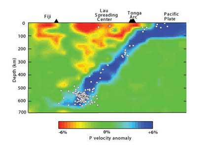
Figure 1 shows a map of seismic velocities we obtained in a similar setting-the Tonga subduction zone. The blue region shows the cold subducting Pacific seafloor going back down into the Earth's mantle [blue areas are where seismic velocities increase because seismic waves travel faster in denser materials, and colder material is more dense than hot material]. The red regions denote areas which are unusually warm and probably represent the source regions for the magma erupted at Tonga volcanoes.
We also want to understand how the earth's is flowing and transporting material from place to place. Finally, we would like to learn something about deep earthquakes. The Mariana islands is one of only about six places in the world where earthquakes occur at depths down to 400 miles. We still don't understand how earthquakes can occur at these depths where the pressure should be so large that the faults theoretically should not be able to move.
How does a seismometer work?
In simplified form, a seismograph consists of a weight that is separated from the ground by a spring.
If the earth moves, as it does during an earthquake, the weight will move differently than the surrounding
seismograph mount which is connected to the ground. A seismometer measures precisely the difference between
the movement of the weight and the movement of the ground. Then we use this measurement to tell us exactly
how the ground has moved. This data is then recorded digitally on a computer disk drive, along with the time
from an extremely accurate clock.
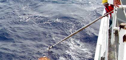
Why do you use ocean bottom seismometers (OBSs)?
We need to obtain measurements with seismographs in all different
directions from an earthquake. Measurements only from land seismographs are inadequate to do this, since most of
the earth in the Mariana region is covered by water. So the OBSs allow us to observe the earthquakes in all the
different directions from the earthquake and thus build up a much more accurate image of earth structure in the
region. The OBSs also allow us to study earthquakes that occur beneath the ocean floor and which may be too small
to be recorded at the distant land seismographs.
How does OBS data compliment/differ from land-based seismic data?
The OBS data is not quite as high quality as land data, since the OBSs cannot be carefully placed in optimum
locations. They are simply dropped off by the ship and are located wherever they settle on the bottom. OBSs also
have somewhat noisier signals due to currents along the ocean bottom, and in some cases the timing accuracy is
not as good since the OBSs cannot receive GPS timing signals beneath the water surface. However, the OBS data is
nearly as good as land data and it provides essential observations from locations where we cannot place land sensors.
How long have these OBSs collected data?
We installed the 58 OBSs in June, 2003 on a cruise of the Japanese research vessel R/V Kaiyo. 50 of the OBSs are
from the US (built by Spahr Webb at Columbia University) and 8 of the OBSs are from Japan (built by Hajime Shiobara
at the University of Tokyo).
How do you retrieve the OBSs?
The OBSs contain sensors that listen for sonar signals in the water. When we send them a certain code sequence, the
OBSs release a lead weight. After releasing the lead weight, the rest of the OBS is buoyant and rises up to the surface,
which takes about two hours. We then bring the ship along side the OBS and pick it up onto the deck of the ship with a
crane.
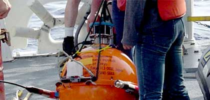
What are the risks with OBSs?
Occasionally an OBS fails to rise to the surface and is lost. This could result from either a failure of the sonar
releasing mechanism, because water gets into the pressure case and destroys the electronics, or because the OBS has
come to rest on the seafloor in an unusual position. Of course the OBS has to operate on the seafloor up to a year
without any checks or repairs and so sometime the data recording system fails.